Today was "Explore Moab" day--or at least the general Moab area. My plan was to hit two national parks and one state park before sunset, and since all three are within 30 miles of each other, this turned out to be pretty easy.
 |
| View from Dead Horse Point |
First up was Dead Horse Point State Park, a recommendation from a friend who used to live near Salt Lake City and is familiar with all things Utah. The park itself is pretty small, and is only a few miles before you get to the entrance of Canyonlands National Park--my second destination, so it was already on the way. There are a few camping sites there, but the main draw of the park (from what I can gather) is the AMAZING view of the canyon at the end of the road. It was only a few miles' drive to get there, and the entire large viewing area had a lot of paved sidewalks that covered roughly 180˚ of viewing area.
 |
| View from Dead Horse Point |
I really hate getting out of my car because taking the scooter out, putting it together, then taking it apart and putting it back into a sedan trunk with a lip (as opposed to my crossover with a flat trunk entry) can be a real pain in the butt. But canyons are a different animal when it comes to a "windshield tour" that I was engaged in. Unlike Monument Valley where all the sights shoot up a thousand feet above the ground, canyons are, well...sunk. If I wanted to enjoy the view, I needed to get out of the car. And OMG was it worth it...
I visited the Grand Canyon about 15 years ago, and I had never (obviously) seen anything so overwhelming. This canyon came pretty darn close, if only because of the snow-capped mountains in the background that presented such a strange and sharp contrast. The Colorado River snaked very slowly along the bottom, which gave the impression that this canyon was the Grand's little brother.
 |
| Canyonlands National Park |
From Dead Horse Point I drove next door to Canyonlands National Park--which is basically a much larger version of the state park. Canyonlands actually has four different sectors, but they're not connected so you have to enter each part of the park through entrances that are dozens of miles apart. The entrance I was using, called Islands in the Sky, has the longest driving loop (I think two entrances are only for campers and serious hikers). Fortunately, the lookout points and vehicle pullouts were abundant, and the views were clear enough of the canyons below that I didn't have to get out of my car--which is really saying something because my selfie stick/monopod that I was using to elevate my phone for pictures died shortly after I entered the park.
The road that goes through Canyonlands is almost like an island (thus the name, I suppose) surrounded on three sides by terraced canyons as far as the eye can see. The colors range from brown and deep red to light orange and tan. The tops of the canyons, like the road I was on, does not betray what lies below. It's all straw-colored grasses and green shrubs, with the occasional juniper tree dotting the landscape. There are some rocky outcroppings here and there, but the surface-level landscape is more or less unremarkable. That's what makes the canyon views, in my opinion, so jarring and breathtaking.
 |
| Canyonlands National Park |
 |
| Arches National Park |
 |
| Arches National Park |
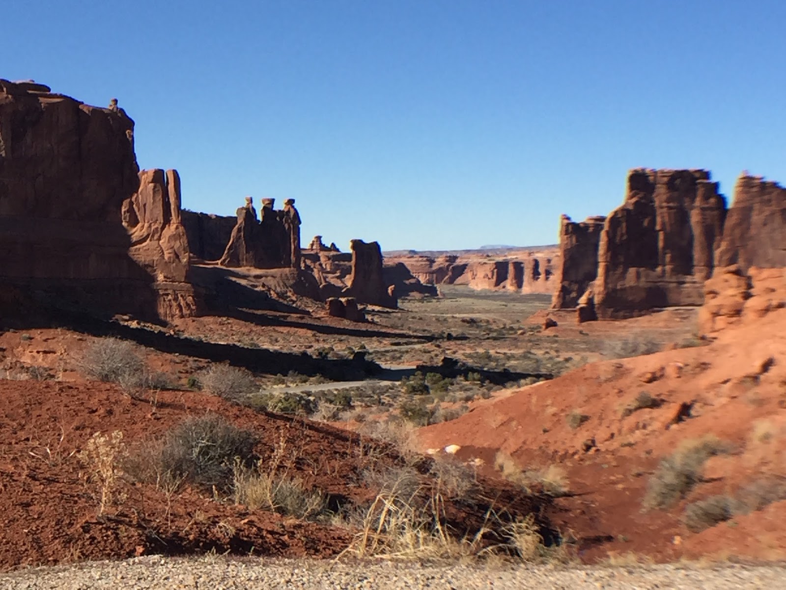
From there it was a 24-mile drive to Route 191, and a short 4-mile jaunt to Arches National Park. Let me start off by saying Arches was NOT what I expected. I got the park guide while going through the entrance gate, and I learned that it's one of the world's largest collections of natural arches. These arches are formed in sandstone sitting on top of a huge shifting salt flat. Over the millenia, rain and wind and ice have done their work with the porous sandstone to form these arches. I expected to see a lot of them, given that the guides say there are plenty which are visible from the road. Two words, people: False and Advertising. I think I saw maybe five arches, and I drove every inch of that park that was drivable. It turns out you have to take hikes/walks of varying lengths and difficulty to see most of the arches.
 |
| Arches National Park |
 |
| Arches National Park |
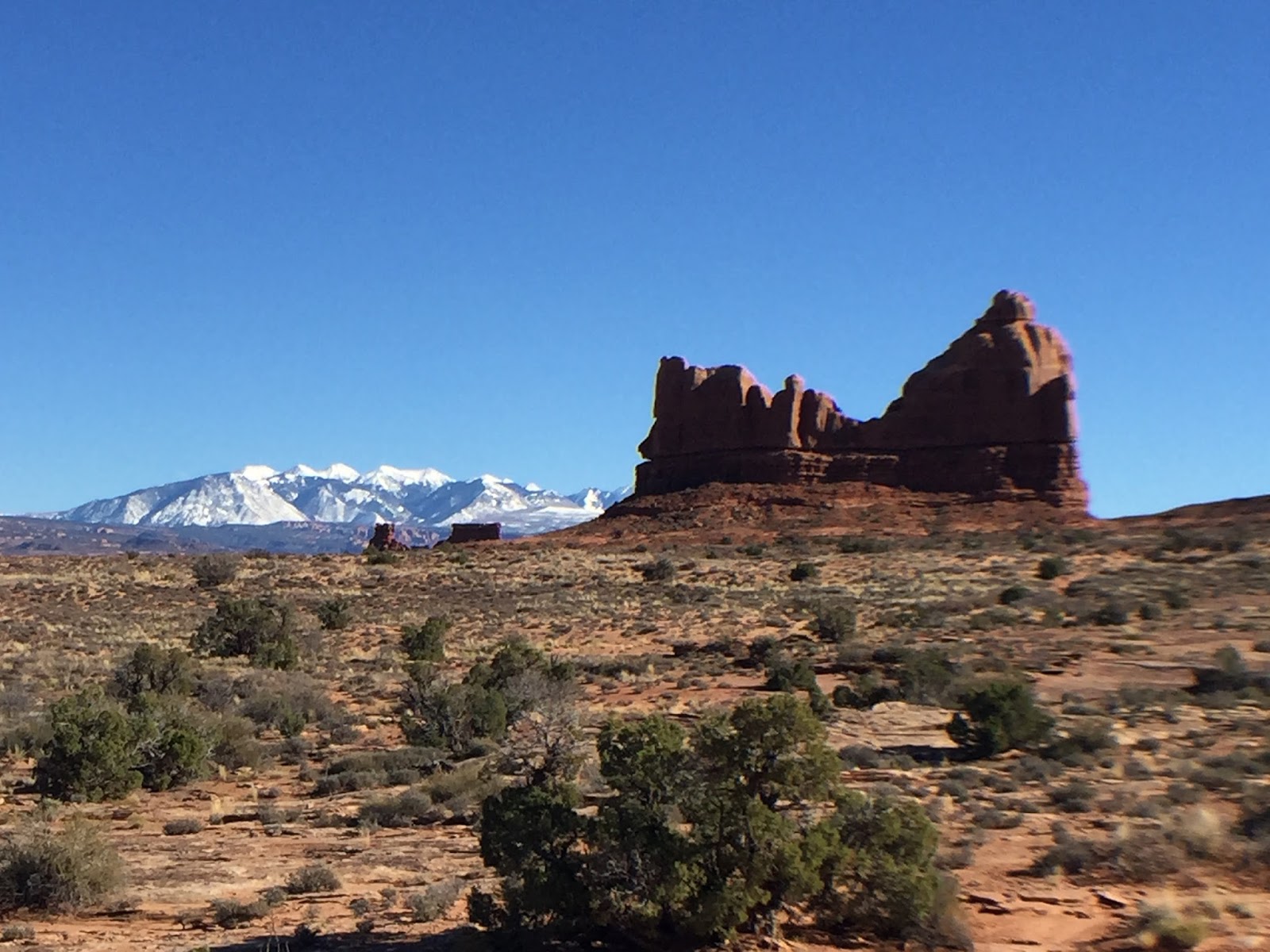
But you know what? It didn't matter one bit. Because Arches gave me even more surprises--the biggest variety of geological formations, terrain, and scenery that I've ever seen in the span of a short 15-mile drive. The spires and buttes are made of two different types of sandstone, so the color is split between the typical deep red and a light tan. Some of them looked like Monument Valley-type formations, and others looked like gigantic versions of my kids' playdoh creations. The park has
petrified sand dunes. Huh??? It has gray/brown/boring salt flats across the street from huge red spires in the forefront with the La Sal mountains in the background. Whaaa??? Disconcerting to say the least, and my head--and steering wheel--were on a swivel trying to capture it all in my brain's and iPhone's memory.
Tomorrow is my last day in Utah, but my adventures aren't over yet. I'll be pulling out of Moab in the morning on my way to Salt Lake City airport for my early evening flight. But I'll be stopping along the way--once again, on the recommendation of a friend--at the San Rafael Swell. Based on the photos, it looks like it'll be a gorgeous stop to break up the five-hour drive!


No comments:
Post a Comment